Loading…

User Guide

How to use pois.world

GPS & Navigation

The GPS button (bottom-right) has 4 visual states:

OFF

Gray — Off

GPS inactive. Tap to start.

GPS

Green blinking — Searching

Waiting for GPS signal. May take a few seconds outdoors, longer indoors.

DOT

Green solid — Tracking

Your position is shown on the map (blue arrow), but the map doesn't follow. You can move the map freely. Tap to start following.

NAV

Blue — Following (Navigation)

Map follows your position and rotates by heading. Like car navigation. Arrow always points forward (up). Drag the map to break follow (goes to green). Tap to stop tracking completely.

Camera behavior

  • First activation: the map zooms to your position at zoom 18 (2D) or ~200m altitude top-down (3D globe). Arrow appears at lower 1/3 of screen.
  • While following: arrow always points up (forward), map rotates to match your heading. Works on both 2D and 3D maps. You can adjust zoom, camera height, tilt — these are preserved.
  • Drag to break follow: map stops following (green dot), arrow rotates on map to show your heading. GPS tracking continues. Camera settings are remembered.
  • Tap to re-follow: the map flies back to your position using your last camera settings (zoom, height, tilt) — it does not reset to defaults.

Map Controls

Pitch slider Right side — drag to tilt the map. Number shows current angle.
Arrows Appear when tilted. Change camera height without moving forward/backward.
Compass Tap to lock north (blue = locked). During GPS follow, switches to north-up mode.
Layers Top-right — switch map style, toggle media/tracks/labels/speed cameras.

Points of Interest

Create POI Right-click (desktop) or long press (mobile) on empty map at zoom 8+.
POI settings Tap any POI on the map to open the settings dialog.
Context menu Right-click or long press on a POI for: Edit, Nearby, Navigate, Copy link, Subscribe, Move, Delete.
Move POI From context menu, tap new position on map.
Quick photo Camera/video buttons on the left (when no POI selected). Creates a POI at GPS position with the photo/video attached.
Access control In the edit dialog, set who can add comments, logbook entries, and photos: Everyone, All Contacts, a specific group, or Nobody.

GPS Tracks

Record Route icon (bottom-right, below GPS). Tap to start recording. Path is drawn live on the map.
Save Tap stop. Enter a name. Track is saved with distance, duration, elevation.
Link to POIs POIs created during recording are auto-linked.

Logbook

A spatial journal — dated entries attached to any POI.

Write entry Activate a POI, tap the notebook-pen icon (solid border). Composer opens with text field and photo/video pickers.
View entries Tap the book icon (dashed border) or scroll down in the POI dialog — logbook section is between tags and comments.
Swipe actions Swipe an entry left to reveal Hide / Edit / Delete.
My Logbook Visit /logbook for a chronological feed across all POIs, grouped by day.

Photos & Videos

Upload Activate a POI, then use Camera / Video / Upload buttons. Photos convert to WebP, videos to HLS/DASH.
Browse /photos or /videos. Toggle Album / By Day views.
On the map Media markers cluster on the map. Filter in Layers panel: All / Mine / Off.
Delete Long-press a photo/video in the gallery for context menu. Only the uploader or POI owner can delete.

Contacts & Access Control

Manage who can see and contribute to your POIs.

Add contact Visit /contacts. Search by email or display name. One-directional — no acceptance needed.
Groups Create groups (Family, Friends, Work). Assign contacts. Groups are private — only you see them.
POI access In the POI edit dialog under "Who can interact": set Comments, Logbook, Photos to Everyone / All Contacts / a specific group / Nobody.

Subscriptions & Notifications

Follow POIs like Telegram channels — get notified about new activity.

Subscribe Open a POI and tap "Subscribe" in the footer. Or right-click / long-press a POI on the map and choose "Subscribe" from the context menu.
Bell icon In the header — shows unread count. Tap to open the notification list. Swipe left on a notification to mark read or delete.
Navigate Tap a notification to fly to the POI on the map.
Manage Visit /subscriptions to see, pause, or remove subscriptions.

Live Location Sharing

Start Activate GPS, then tap the share icon (next to GPS button). Set your name, status, duration, and who can see you.
On the map Others see your position as a blue person icon with your name and status.
Stop Tap the blue share button to stop. Marker removed instantly.
GPS off "Remove from map" — sharing stops automatically. "Show last position" — button stays blue, tap to remove.
Last position Choose "Show last position" to keep your marker visible after you stop or close the app. Stays until the share duration expires.
Privacy You explicitly start sharing. No position history stored. Auto-expires after chosen duration. App crash cleans up immediately (unless "Show last position" selected).

My Action POIs

Open Tap the POI counter in the map header (e.g. "992 POIs").
Pin Tap the pin icon on any row to keep it at the top. Persists across sessions.
Swipe Swipe left for quick actions: View, Logbook, Navigate, Pin, Delete.
Context menu Long-press (mobile) or right-click (desktop) for the full action menu.

Layers Panel

Tap the Layers button (top-right) to control what's visible.

Photos on map All / Only mine / Off
GPS Tracks All / Only mine / Off
Alarms Speed Camera alarm toggle
Labels Peaks & places, OSM POI labels

Active POI Buttons

When a POI is active, two groups of buttons appear on the left:

Solid border Create / add content — Camera, Video, Upload, Logbook write, POI settings.
Dashed border View existing content — Comments, Gallery, Logbook view.

3D Globe (Cesium)

Controls Left drag = orbit. Right drag = tilt. Scroll = zoom.
Layers Satellite, Map (OSM), Auto (Google 3D tiles where available).
Places Fly to famous places (Everest, Grand Canyon, cities).
Celestial Sun, Moon, Comet, planets — tap to look at them.
GPS Same 3-state GPS button as 2D map. Flying to a place breaks follow.

Mini-apps

A mini-app is a small service that writes into your POIs — a weather line in a note, a daily space picture, a Telegram channel mirrored into a logbook. Each one runs on its developer's own infrastructure; pois.world only holds the contract between you and it.

  • Installing: open Mini-apps, pick one from the directory, or paste the manifest URL a developer gave you. You see exactly which permissions it asks for before anything is installed.
  • Controlling: every installed app can be paused (⏸), configured (⚙) or removed. Per-POI you can switch an app off for that place alone, in the POI's Settings dialog.
  • Seeing what it did: entries an app wrote are marked with its name, and each app's "How to use" explains its own behaviour in plain words.

Building one

A mini-app is two things: a manifest you publish (JSON at a URL of your choosing, e.g. https://your.app/.well-known/pois-miniapp.json) and an HTTPS endpoint we call. The manifest declares the app's id, title, description, the permissions it needs and the events it wants; the user reads that list at install time and decides.

  • Permissions are narrow on purpose — e.g. writing logbook entries as the installer, or reading a POI. Ask for the least you need; the install screen shows every one of them.
  • Events are delivered as signed webhooks (an X-MiniApp-Signature header over the body) so you can verify the call really came from pois.world.
  • Nothing is hosted here. Your service stays yours: we call it, it calls our API with the token issued at install.
  • Want the full contract (manifest fields, permission list, event payloads, signature recipe)? Ask us — the developer reference is shared on request while the platform settles.

Future Ideas

We're experimenting with photorealistic 3D city layers using the Cesium rendering engine. Explore real-world buildings, streets, and landmarks in full 3D — directly inside pois.world.
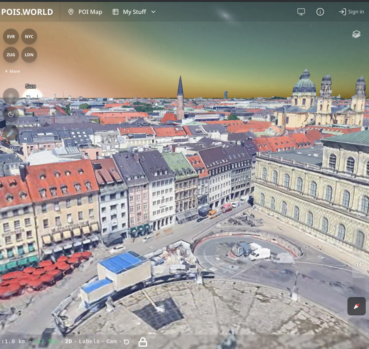
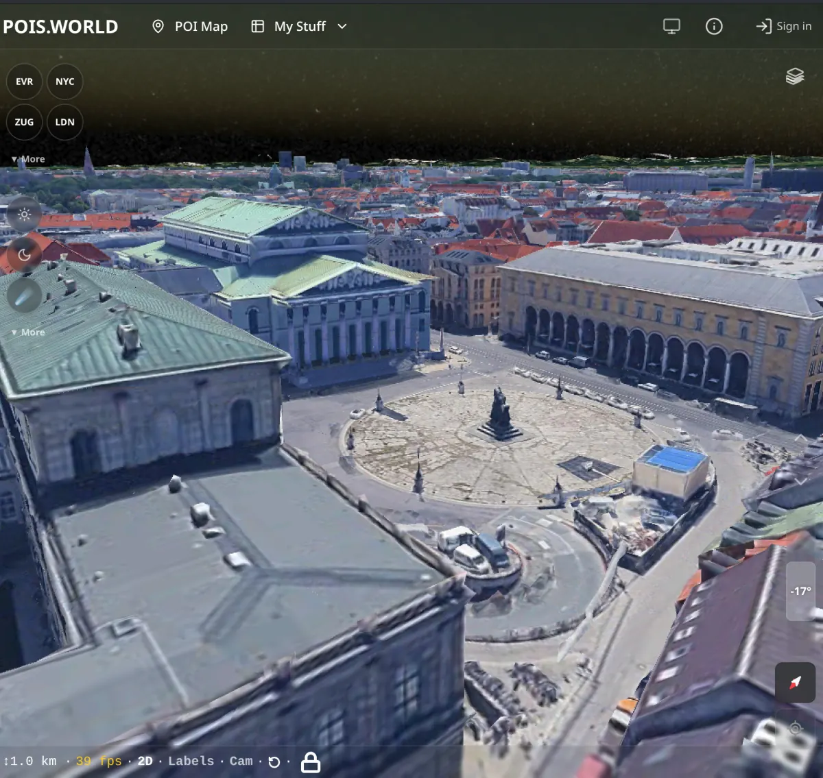
Photorealistic 3D city view — Munich from above Photorealistic 3D city view — Munich square

Coverage is expanding — major cities worldwide are available in photorealistic detail. Your POIs, tracks, and photos are visible on the 3D globe too. Try the 3D Globe →